Showing posts with label River Trent. Show all posts

Tuesday, 23 November 2010

Cooling Towers

From one ex-industrial site to another...


Willington is a small village just south of Derby. The name originates from the old English tun meaning a farm or homestead, among the willows. It is situated beside the river Trent and has a population of approximately 2,700 people and five cooling towers.

Once upon a time, those cooling towers were accompanied by chimneys and all of the other infrastructure associated with a fully functional coal fired power station. This location was an obvious choice. Water was in ready supply from the River Trent and the nearby Nottinghamshire and Derbyshire coal field would provide the coal. The bulldozers moved in in 1954 and preparation began on the land between the B5009 and the Derby to Birmingham railway line. The first unit of the A station was commissioned on 17th December 1957 and the station was officially opened on 2nd October 1959 by the 11th Duke of Devonshire. 


During the 1980s, there was a series of open days, which were extremely popular. I regret that I didn't ever go for a look.

Privatisation in 1989, was the beginning of the end, with the first unit closing in January 1993 and the final unit seeing decommissioning on 31st March 1999.

Demolition of the site began in November 1999, until all that was left were the five cooling towers. And, 11 years later, still they stand, 300 feet high,with a diameter of 145’at their tops and 218’ at the base.

Monday, 8 November 2010

Repton School


Repton School occupies a number of buildings within the village, some historic (the 12th century Augustinian Priory forms the heart of the school), some much more modern and purpose built. Drive through here any weekday during term time, and there are almost certain to be students walking around the village, looking smart in their uniforms, carrying books and folders; each looking every inch the academic!


Repton caters for around six hundred students aged between 11 - 18 and organised into 10 houses, which become their term time homes and families; particularly for the Boarders.

The school prides itself on it's academic standards claiming that high expectations coupled with rigorous monitoring and quality teaching, will enable children to reach levels beyond their expectations. Alongside academic achievement are opportunities to excel in the arts, sport, music and drama; to become a rounded person and find the niche in which they will enjoy success.

The chapel is also an integral aspect of school life, promoting Christian values of service and giving the opportunity for the school to celebrate the Repton community.


Doesn't it all sound wonderful? The ideal to which any parent would aspire! The perfect start in life for their offspring!

In many, many ways, I expect it is.

My question is...

Why can't all secondary schools in our country enjoy such success?
Is it fair that some children have a privileged standard of education just because their parents can afford to pay the £9,050 per term for a boarder, £6, 715 per term for a day student?

(That's £27,150 per year for a boarder. Allow for seven years of school life, including the inevitable sixth form studies which will follow from their GCSE success, and that equates to a cool £190,050 - plus add ons like uniform, educational visits etc, and not factoring in rising fees!)

OH MY WORD!!!

Opinions anyone?


Sunday, 7 November 2010

Stone crosses

Not surprisingly, the churchyard of St Wystan's is full of crosses; markers erected in memory of people loved and lost, some dating back many years and some final resting place for generations of the same family.


The cross: an instrument of torture and death, become a symbol of life and hope.

Saturday, 6 November 2010

St Wystan

 
I believe that I am correct in saying that there are only four churches in Derbyshire named after Anglo Saxon saints; St Oswald, in Ashbourne, two St Alkmund's, in Derby and in Duffield and this one in Repton, named after St Wystan.

Oddly, we know more about Wystan after his death than we do before it.

Wystan, who is also known as Wigston, was a Mercian prince, son of Wigmund and Ælfflæd and grandson to King Wiglaf. In 849, Beorhtwulf arranged the marriage of his own son, Beorhtfrith, to Wystan's mother. This was a clear attempt to gain succession to the Mercian throne and Wystan objected to the match. As a result, Beorhtwulf had Wystan murdered.

Wystan's remains were buried in the mausoleum at Repton and that is when odd things began to happen. A column of light appeared, shooting up into the air from the place where Wystan was buried and remaining for thirty days. This led to the canonisation of Wystan, which in turn led to the visits of pilgrims, to the extent that new stairs had to be cut to the burial chamber allowing free flow through the crypt; a Saxon one way system.

When the Vikings invaded and wintered here (873-74), Wystan's body was taken away by escaping monks, but returned again after the Vikings left. Then eventually, King Cnut (1016-35), had the remains of St Wystan moved to Evesham, where it is said that further miracles took place.


The crypt of St Wystan was long buried and forgotten, until in 1779 it was rediscovered by a workman who, whilst digging a grave in the chancel, quite literally fell through its roof. Over the centuries, other parts of the church building have been added or altered, particularly through the 13th and 14th centuries. Then, during the 15th century, the tower and spire were constructed, rising to a combined height of 212 feet...


... exactly the same height as the tower of Derby cathedral!

Friday, 5 November 2010

Repton cross and a roof of straw

Repton is a large village lying on the south bank of the river Trent, about 6 miles from Derby. In 2001, it numbered 1,658 households with a total population of 4,635.

There are two particular details about this village which make it's name known much more widely than would be expected for a settlement of this size. One is that it is the setting of a notable independant boarding school, but by far the more interesting fact is that it was the historic capital of the Saxon Kingdom of Mercia, a significant area which stretched between the rivers Mersey and Humber in the north, to Severn and Thames in the south, running the length of the modern Welsh border (it was King Offa of Mercia who built the famous Dyke) in the West, but excluding the hump of modern East Anglia and Essex to the East.

Between the 7th and 9th centuries, Hrewpandum (Repton) was a principle residence of the royal family of Mercia. It was during this time that Christianity came to the Midlands, brought by monks from Lindisfarne who came when Elfleda, daughter to the King of Northumbria, married Paeda, son of King Penda of Mercia. 


Repton Cross was the site where they first preached. The date attached to this occurance is 653AD, just 56 years after Augustine first arrived in England, sent by Pope Gregory I to introduce Christianity to Britain.


Still a significant landmark in the village, the cross was once the centre and site for the regular markets and fairs which took place until the end of the 19th century, and on 2nd September 1952, it was designated a grade I listed monument. Restored in the 17th and 19th centuries, the Cross is made of sandstone, with a flight of eight steps leading up to an octagonal base, topped by a  circular shaft and ball finial. The reference to it as a cross, refers to the meeting of the four roads, rather than the nature of the monument itself.

This is how the Cross looked in 1890, dominating the central area of the village. 

File:ReptonCrossAndChurch.jpg


Just around the corner from the cross, and opposite the church are these thatched cottages which date back to around 1700.


Wednesday, 27 October 2010

Two fords and a ferry

So where did Twyford lane once go?


It forded the river of course :)


Until the Willington Bridge was built in 1839, there was no dry crossing over the river  between Burton-upon-Trent, c8 miles upstream of Twyford, and Swarkestone, c4 miles down. The relatively shallow water at Twyford made it one of few places where it was possible to cross in reasonable safety and the Trent is known to have been forded here since Roman times.

The name Twyford actually means two fords as there are two possible crossings at this point. Nevertheless, standing here looking across the river, I can guarantee that I would not have wanted to try either! 


At some point, the ford was superseded by the ferry.

The boat used was a chain ferry, hand-winched across the river along the course of a chain fixed between two posts. The original posts are still in place on either bank. One can be seen just behind the plough, now being used as a lifebelt stand.


Records do not show the exact date from which a ferry was installed, but it was used in 1790 by John Byng, fifth Viscount Torrington (1743-1813). Torrington was a famous diarist and refers to the ferry in his travel journals, 'The Torrington Diaries' (published post-humously in 1934). There is also an even earlier reference to the existence of a ferry, made by William Woolley in his historical writings of 1712.

As well as travellers, the ferry was used by locals who grazed their cattle in pastures across the river and, slightly more unusually, as a hearse after the self-hanging of a stranger in the village. The body was ferried across the river to be buried because a suicide could not be laid to rest in the consecrated ground of the church graveyard.


The photograph below, shows the ferry in action in 1899.


Then, in 1962 -3 came the coldest winter for 200 years. It brought blizzards, snow drifts, blocks of ice, and temperatures lower than -20 °C, beating the Great Freeze of '47 and becoming the coldest on record since 1740. The months of snow and relentless cold finally ended in March of 1963, beginning with a south westerly breeze which rapidly took temperatures up to 17 degrees celcius. The resulting thaw brought widespread flooding which, amongst many other more significant consequences, washed away the Twyford ferry.

Having been made somewhat redundant by the building of the bridge at Willington (2 miles upstream) and due to the fact that it was not suitable for cars, the ferry was never replaced. 

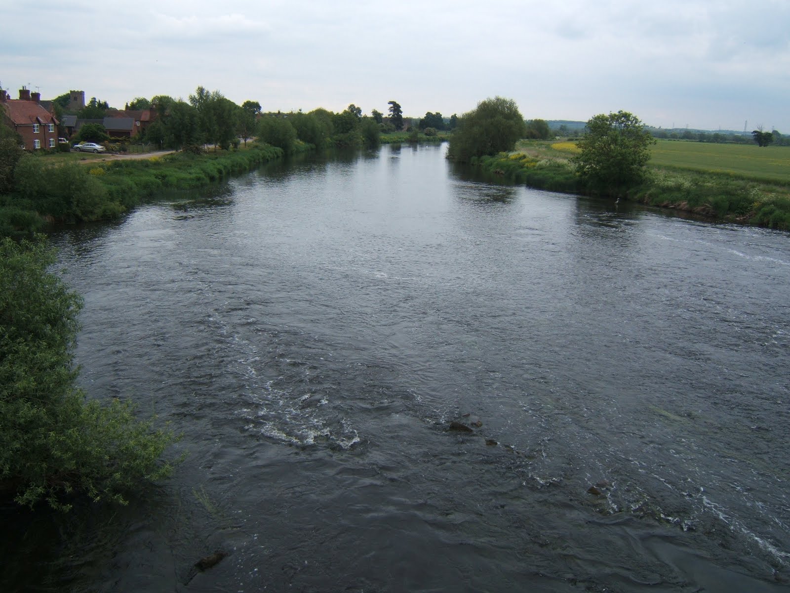
Now the river is empty and quiet as it rolls by slowly, reflecting the autumn sunshine.


Time to drift over to Jenny Matlock and see what other posts are on offer for Alphabe-Thursday and the letter F.

Tuesday, 26 October 2010

Twyford


Six miles south of Derby is the tiny village of Twyford. It's quite close to home but a place I haven't visited for years, the reason being that it's at the end of a lane which goes no-where else - not any longer anyway! (I'll explain tomorrow)

Since 1977, Twyford has been a conservation area and the village is quite a pretty little place, but I did feel a little awkward wandering around; it has a very private feel to it, almost as if it's been forgotten by the rest of the world.

Twyford has a long history. The parish was referred to in the Domesday Book of 1086, although no church was recorded here at that time. In 1563, the joint population for Twyford and Stenson was recorded as 148. Today, Twyford is recorded separately, the 1999 Electoral Roll figures showing it as having 19 households, totalling 101 inhabitants.

The village is served by the church of St Andrew, a medieval build with a Norman chancel arch. The tower shows signs of being built in three stages, the lower part probably dating from the early 13th century and the upper sections from the 15th century. The slightly incongruous looking brick nave is the result of rebuilding in 1735 after the church fell into disrepair. The bricks are the Georgian outer facing of the existing masonry.

Inside the tower are three bells, one of which is dated 1611.


Parish records date back to 1658 and the church is accompanied by a graveyard, which tells stories of its own.


Once, the village also boasted a school and a pub; the Blue Bell. The school was built in 1843, but closed 100 years later because of it's small size; it's children being relocated to nearby Findern. The Pub was earlier, meeting its demise in 1850, when it was demolished by Sir John Harpur Crewe because it was becoming a notorious meeting place for poachers.

Other modern amenities were slow to reach the village. Electricity was only connected up here in 1939 and mains water did not arrive until 1959. To put that into context, that's only two years before Yuri Gagarin became the first human to travel into space!

Monday, 7 June 2010

River Trent


Looking west from Swarkestone bridge, the waters of the River Trent run relatively smoothly. By this point, they have flowed from their source between Biddulph and Biddulph Moor, through Stoke on Trent and Burton on Trent (all in Staffordshire) and skirted most of south Derby.


East, is looking towards Nottingham, around fifteen miles distant. Beyond Nottingham, the river turns more sharply north, heading for the Humber; in total, a length of 171 miles, making it the third longest in England.

It is interesting to notice that the water over this side of the bridge is choppy. I assumed that there were rocks below the surface. I was almost right.

Although Swarkestone Bridge is an ancient monument (see this post), the same is not true of the part of the structure which crosses the river itself. The ancient section is the causeway which is around 3/4 of a mile in length. The river bridge dates from the eighteenth century, replacing a much earlier version. It is the earlier bridge which is the cause of the rough water. When it was demolished to make way for this one, the rubble from the old bridge was allowed to fall into the waters of the Trent and was then left there; causing the previously calm water to suddenly have a bit of a rough ride. Regulations were obviously not as tight in those days!

The other thing we spotted across the east side of the bridge was this heron...


...which posed politely whilst keeping a sharp look out for fish! (It's a beautiful bird and much better standing here than trying to steal the koi carp from my uncle's pond!!)

Tuesday, 1 June 2010

Swarkestone Bridge

As I said in my post yesterday, Bonnie Prince Charlie's men may have drunk in the Dolphin Inn, but they can't have known that they were within a few short miles of the southernmost point of their journey, which came here, 6 miles south of Derby, at Swarkestone Bridge.


Built in the 13th century, this bridge remained the primary Midland crossing over the River Trent for around 300 years. The bridge itself is almost a mile long and has 17 arches, the reason for this being that the river was edged by an area of wetlands over which the bridge extended; more like a causeway than a bridge proper.


Being a major crossing made it a strategic location in a military campaign. In 1643, it was defended (unsuccessfully) by the Royalists against the Parliamentarians and, in 1745, the advance guard of the Jacobean rebellion was sent here to take control.

The Jacobean army was not strong and, although enough clansmen had been roused to march with Prince Charles Edward Stuart, his generals were looking for support from the south or from France. As this appeared to be unforthcoming, the generals decided to retreat (against the wishes of their leader).

What they did not know was that the English were singularly unprepared for an invasion with most of their troops abroad and King George himself preparing to flee to Germany just from the news of the Jacobean marching. If the march had continued, it would almost certainly have been successful and English history would have taken a very different path. (One wonders if this is one of those 'fixed points in time'. Dr Who fans will understand.)

As it stands, all we have is a slightly overgrown cairn, erected to mark the southernmost point of the march of the Jacobean rebellion.


Sunday, 28 March 2010

Following the course

Isn't it interesting, the way the same small stretch of river can look so different depending on the direction from which it is viewed?

Standing on the footbridge, this is the view looking north west:


But, personally, I much prefer the view to the south east...


...with the sunlight shining through the still-bare branches and reflecting off the surface of the seemingly still water.

Whichever way it is viewed, this is the fledgling river Don, which rises as a series of small rivers in the Pennines, around Grains Moss, on the borders of Yorkshire and Derbyshire. These converge to form the source of the Don proper, which almost immediately feeds into Winscar reservoir; one of Yorkshire Water's larger reservoirs situated near Dunford Bridge.

From here, the Don winds it's way east through Penistone, and then in a southward loop under the bridge where we were stood and on to Sheffield and Rotherham. Leaving the conurbation, it turns north-eastwards towards Doncaster (not surprising considering the name) before finally mingling its waters with the Yorkshire Ouse at Goole. Originally, the Don was a tributary of the Trent (which also joins the Ouse, 10 miles further downstream) but in 1627 it's route was changed by the Dutch engineer Cornelius Vermuyden, for the purpose of making it navigable for coal barges. Although navigable rivers have largely been superseded by railways and motorways, the Don can still be travelled from Goole as far as Sheffield.

In total, the course of the Don is 70 miles, making it 20 miles longer than Derby's River Derwent which also rises within a few miles of Winscar Reservoir, but on the more southerly slopes of the Pennines.

I find it interesting that the two rivers rise so close together and both end up in the North Sea via the Humber, yet follow such different courses during their 'lives'. I'm sure that there is an analogy there somewhere.