Thursday 30 June 2011

Kayaking on Carsington Water

My personal challenge for this round of Miss Jenny Matlock's alphabe-Thursday is to post about a location within the borders of my own county of Derbyshire, UK, for each letter of the alphabet.
Look for the letter, to see where I am.

 
K is for kayaking at Carsington Water.
 
------------------------------------------------------------------------------------------------------------
 
There are lots of  places I could have chosen for K (Kirk Ireton, Kirk Langley, Kniveton, Kedleston, Kings Newton...) but it was just too much of a co-incidence that the letter K rolled round four days after Ben and I spent the weekend at Carsington Water doing a kayak course.


It is beginning to feel like Carsington Water has been here forever, but it is actually only the same age as my eldest son; 19. Before construction was begun, some of the land which is now flooded belonged to my aunt and uncle's dairy farm. It's funny to think that I have walked around on what is now the bottom of the reservoir.

The reservoir draws water from the River Derwent when levels are high and returns water to that river when levels are low. It holds 7,800 million gallons, is the ninth largest reservoir in Britain and, by regulating the Derwent, supplies water to 3 million people across the East Midlands. At its deepest, it is 31m deep and the perimeter is around 8 miles.

As well as supplying drinking water, the reservoir is a centre for watersports, with a purpose built Watersport Centre on the shores of the bay...


...close by the main Visitor Centre.


All of the kayaks are Pyranhas; short manoeuvrable boats like the ones used on rivers, rather than the longer tourers or sea kayaks.


I spent the two days in a blue Acro-bat kayak. Ben switched from an orange and yellow G:3 on Saturday to the blue on Sunday; just for a change.


Just to confuse you, the paddle by the kayak is actually a canoe paddle, not the one for the kayak, but we did finish off our weekend with about 2 hours in the Canadian canoes, applying the kayak strokes to the open top craft.


Oh look! THERE'S a kayak paddle! (and the drums stacked up behind are used for raft building)


 All of the instruction happened in the relatively calm water of the bay close to the centre, but Sunday began with a journey round the shores of the reservoir, heading out through the gap between the shore and the island. Crossing the entrance to the sailing club was interesting; a bit like waiting to cross a dual carriageway on a bike! Sunday was HOT and the Water was busy with sailing boats of all shapes and sizes.


The final length of the journey was across the end of the lake following the orange buoys, just beyond the windsurfers in the photo above.


The buoys mark the end of the area accessible by boats (except fishermen) because the whole northern end of the Water is a nature reserve and that is definitely the best end to walk round!


Saturday 25 June 2011

Why not?

One of the great things about being on holiday is that there is more freedom; the freedom to say 'Why not?!', so, why not nip just down the road from Tremadog to Porthmadog to buy Chinese take-away, and take it 4 miles down the coast to the lay-by where we could sit and eat looking over Criccieth castle. Dark? So what?


Since 2006, one or both of the lads have been going to Criccieth for the annual Pathfinder and/or CYFA camp. They have loved it and this place will always hold a special significance for them.

So, Chinese eaten and back to the tent. Yes?

Not quite because, while we are out, why not drive over Pen y Pass to have a look at the mountains in the dark? And so, we ended up back in the lay-by with the view of Snowdon (causing some consternation to the family illegally settled down for the night in their camper van - 'No overnight parking!' Worried faces peeped out through the curtains to make sure our car wasn't sporting a blue light and the word HEDDLU).

No clouds enshrouding Snowdon this time!


And we eventually crept off to leave the campers in peace.

A couple more days off posting (What again?) because I am going up to Cumbria to collect Mark.

Friday 24 June 2011

Yet more climbing

Back down to the foot of the crags and it was Ben's turn to lead a route. He chose a relatively easy one because he was going to be followed up by a novice.


Mark belayed him up...


...and was then on hand to shout advice and instruction to the inexperienced second...


...who was delighted to reach the top.

Thursday 23 June 2011

John Thompson

My personal challenge for this round of Miss Jenny Matlock's alphabe-Thursday is to post about a location within the borders of my own county of Derbyshire, UK, for each letter of the alphabet.


Look for the letter, to see where I am.


J is for John Thompson.

-------------------------------------------------------------------------------------------------------------

This week's post is closely linked with the one from last week, focusing on the pub and brewery, just outside the village of Ingleby.


It began life as 15th century farmhouse, but in 1968, John and Ann Thompson converted their home into a public house and, uniquely, named it after themselves; a UK first!


Being a 'Free House' means that they are not tied to any specific brewery and from 1977 they have brewed their own beer; the very first brew being to celebrate the Silver Jubilee of HM Elizabeth II. Their's is now the longest established micro-brewery in the country, producing beers mainly for sale on their own premises.


Unusually, food is only served at lunchtimes, but that hasn't stopped them from making it into the Good Pub Guide for all 25 years of that publications existence; one of only 66 UK pubs to achieve this.


More recently, the John Thompson have teamed up with a small Derby based company to provide Scandinavian lodge accommodation. The lodges are available for short or long term renting by anyone (up to a maximum of 4 people per lodge), but I suspect they are quite popular with fishermen, as the River Trent is just across the field. (The pub can just be seen in the top-centre of the photograph below).


Back to the pub roadside and there is a lovely show of poppies along the beer garden wall.


Anyone fancy a pint of J.T.S. XXX ?
                                  

Wednesday 22 June 2011

A crag with a view

From the top of the crags above Tremadog, the view was spectacular. 

Starting from the North East and moving clockwise...

1. Cnicht 


The pinnacle of this mountain makes it very distinctive, especially from the south west, but in reality, Cnicht is a long ridge with a pointy bump at the end. At 2,260 feet it is not especially high; certainly not high enough to join the Welsh 3,000s, but it is a rewarding walk. The name Cnicht comes from Old English, rather than Welsh, and means Knight. Years ago, when I stayed at Tremadog on a school residential, the dormitory I stayed in was named Cnicht.

2. Moelwyn Mawr


At 2,526 feet, Moelwyn Mawr is higher than Cnicht, though still not a 3,000. Its summit overlooks the Vale of Ffestinniog and its small high lake, Llyn Stwlan is used as part of the water source for the hydro-electric power station at Tanygrisiau. Moelwyn Mawr is Welsh and translates as 'Great White Hill'.


3. The Cob


The Cob is a sea wall causeway built in 1811 by William Maddocks. It stretches for 1.4 miles, spanning the mouth of the Glaslyn River, and carries a road, a cycle path and the Ffestinniog narrow gauge railway. The Cob was constructed to reclaim the land of the Treath Mawr from the sea and it was on this reclaimed land that the town of Portmadog was built. Until 2003, the Cob was privately owned and charged a toll. Because it had been set by an Act of Parliament when permission to build the Cob was granted, the toll continued at a fixed rate for almost 200 years - 1 shilling (latterly 5p) per car! Now, the Cob has been purchased by the Welsh Assembly and the journey is free.

In the foreground, you can see the ongoing construction of a new road; a by-pass which will hopefully relieve some of the traffic congestion in Porthmadog and improve the town immensely.

4. Criccieth Castle


Finally, looking south west, down the Llyn Peninsular, is the unmistakable shape of Criccieth Castle, about which I have posted before.

Tuesday 21 June 2011

Back to Tremadog and the sun stayed out!


This two days later when we made a return trip to Tremadog. The climbing was good and the views were spectacular. More on the views tomorrow, but this is Mark leading an E1 grade climb, seconded by Ben.


I took the easy route, round the end of the crag

Monday 20 June 2011

Yr Wyddfa

On the A498, a little above Llyn Gwynant, there is a lay-by. In the lay-by is this curved slate marker, sketching out the view upon which you can gaze; the centrepiece of which is Yr Wyddfa (Snowdon 1085m, 3,560ft) the highest point in Wales.


It was after Snowdon that the National Park was named. Formed in 1951, Snowdonia was one of the first National Parks to be created, following hard on the heels of the Peak District (which was first!) and the Lake District. The formation of these parks was made possible by the National Parks and Access to the Countryside Act of 1949 (something else I have learned about while helping Ben to revise!).

Unlike in other countries, our National Parks are not owned by the government. They are living and working landscapes which are protected by law because of their natural beauty and the opportunities they provide for outdoor leisure. Each National Park has its own Park Authority which has legislative powers and responsibilities to protect the landscape and to promote understanding and education, the aim being to ensure these areas are still around for the enjoyment of future generations.


And so, people pull off the steep winding road to admire the beauty of Snowdon; its pointed peak towering majestically over the landscape against a backdrop of clear blue sky...


...


...


...


...


...


Oh, c'mon! What did you expect? This IS Wales!

Last time I was on top of Snowdon... (but I think I've told that story before!)

Sunday 19 June 2011

St Mary's Tremadog


St Mary's church (Eglwys y Santes Fair), Tremadog is one of the earliest Gothic revival churches in Wales. It was completed in 1811 and is located on a rocky outcrop just below the main market place, in the heart of the village. It was paid for by William Alexander Madocks, founder of Tremadog and is now a grade 2 listed building.

The first time I saw this church was on a residential with my school Christian Union. We visited a mountain centre (no longer in existence) just down the road. In those days the church was still open, though I never went inside.

However, in 1995 the church was closed, and Cyfeillion Cadw Tremadog (Friends of Tremadog) began working to find an alternate use for the building. In 2003, permission was granted to convert the building to mixed use, with offices on the ground floor and the first floor being given over to a large meeting room for community use.

It is sad to see local churches close, but I am glad that the building has been saved and given a use which will benefit the community.


Saturday 18 June 2011

Every cloud...


Indoor climbing is good when the weather is wet, but what Mark really wanted was some outdoor climbing so, with both of the lads being fed up of slate, we headed for the crags above Tremadog.


This rather attractive gate marks the start of a short but steepish climb up to the rock face.

Unfortunately, half way up the fields, what had been a promising afternoon turned to a sudden and fairly convincing downpour! Fifteen minutes of bouncing rain meant that the rocks would be far too wet for climbing, but we decided to go take a look anyway and I'm delighted that we did because the woodland at the top was particularly beautiful, glistening in the weak sunshine which followed the storm.


And the waterfall was gushing.


Friday 17 June 2011

Beacon

So, what do you do on a damp day in Wales?

Visit the Beacon Climbing Centre for a bit of bouldering...


...and a lead climb or two.


Thursday 16 June 2011

A few days of being intent

As part of our family week, we decided to break out the tents and spend a few days in Wales; specifically, at Llanberis, a large village overshadowed by the bulk of Snowdon (the highest mountain in Wales).


Of course, the trouble with mountains is that they attract cloud and rain...


...but after a couple of damp days, the sun broke through.


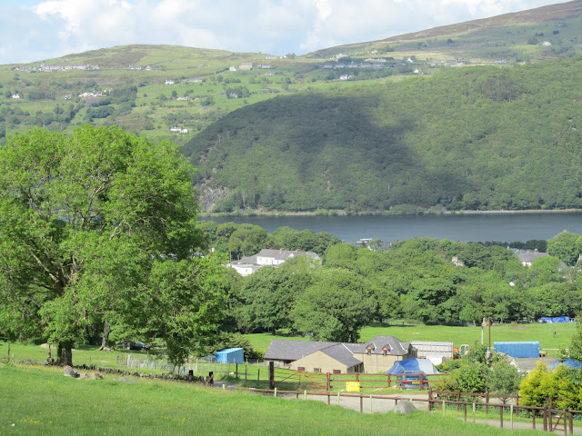
The campsite was very basic; a working farm with field space for tents and one small toilet/shower block. The worst factor was that all of the fields sloped. We found the flattest available space we could, but it was still interesting keeping stuff on the table and I woke up a few times each night to shuffle back up to the top side of the airbed!

But with views like this from the front door of the tent, can I really complain?


The lake is Llyn Padarn. More about that later :)

The other joy of staying on a working farm was the animals. With about 11 million sheep in Wales, it was not surprising to find them wandering around just outside the tent door. We were also visited by hens, sheep dogs and the odd farm cat.


The one animal which really made its presence felt was the cockerel; to the extent that someone had graffiti ed the inside of the toilet door with the words "Someone shoot that bloody cockerel!". Awwwww. Only at 4.30am!!